
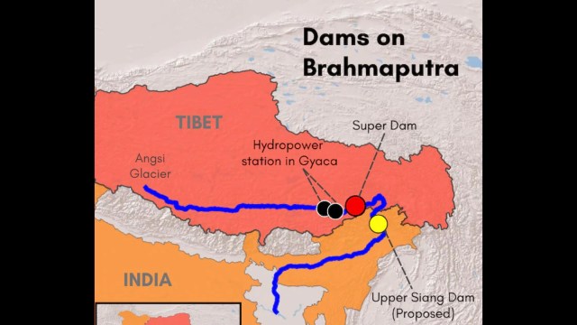
The Brahmaputra River has become the newest flashpoint between India and China. Beijing broke ground in July 2025 on a $167 billion hydropower dam on the Yarlung Tsangpo in Tibet, the river that becomes the Siang in Arunachal Pradesh and the Brahmaputra in Assam.
India told Parliament that China has not shared hydrological data on the river since June 2023, and a government analysis reviewed by Reuters warns that dry season flows could fall by up to 85 percent once the dam is operational. The stakes stretch from farms in Assam to fishing communities in Bangladesh, and now to villages in Arunachal Pradesh that are resisting India’s own counter-dam.
Why is this dam on the Brahmaputra so worrying for India?
China started construction on what it calls the Motuo or Medog Hydropower Station on July 19, 2025. Premier Li Qiang led the groundbreaking ceremony at Nyingchi’s Mainling site in the Tibet Autonomous Region. The project will have five cascade power stations with a combined capacity of about 60 gigawatts, generating an estimated 300 billion units of electricity every year, more than Britain’s total annual power output.
The dam sits just before the Yarlung Tsangpo bends sharply and enters Arunachal Pradesh as the Siang, later becoming the Brahmaputra in Assam. This location matters enormously to the Brahmaputra River’s downstream future, because it gives Beijing physical control over water leaving the Tibetan plateau at the exact point where the river drops nearly 2,000 metres in 50 kilometres, its most powerful stretch.
Can China legally starve India of Brahmaputra water?
There is no binding treaty that stops China from altering flows on the Brahmaputra River. India and China are not signatories to the United Nations Convention on the Law of Non-Navigational Uses of International Watercourses, which sets global norms for shared rivers. Their only formal arrangement is a technical Memorandum of Understanding for flood season data, not a water allocation treaty. Beijing has repeatedly said the project is a run of the river scheme that will not divert water and falls entirely within its own territory. India cannot legally compel China to release a fixed quantity of water. What India can do is raise the matter diplomatically, build storage to buffer against sudden changes, and press for greater transparency through existing mechanisms.
Is China using water as a strategic weapon against India?
The Indian government has not accused China of weaponising water, and Beijing denies any intent to harm downstream regions, saying the project is about clean energy and local development. But officials in New Delhi see two risks. The first is a slow squeeze on dry season supply, when Assam already faces its leanest flows. The second is upstream control that could, in theory, be used to release water suddenly. The Indian government analysis reviewed by Reuters found the Chinese dam could allow Beijing to hold back or divert as much as 40 billion cubic metres annually, roughly a third of what India receives at a key border point. Whether this amounts to intent or infrastructure risk remains a matter of debate, and no Indian official has publicly used the term “water weapon.”
What happens to Assam if China controls the tap?
Assam depends on the Brahmaputra for irrigation, drinking water, inland navigation, and hydropower, and around 30 percent of the river’s flow within India comes from glacier melt and rainfall in the Tibetan catchment, with the remaining 70 percent fed by Indian tributaries such as the Subansiri, Lohit, and Manas. An 85 percent dry season flow reduction at the border point, if it materialised, would still leave Assam’s monsoon-fed tributaries functioning, but the lean season months from December to April, when river levels are already at their lowest, would see sharply reduced water for irrigation, drinking supply schemes, and the run of river hydropower stations that Assam depends on. Guwahati’s own dry season supply gap could widen without India’s counter-dam in place, according to the government’s internal projections.
Why doesn’t India have a water-sharing treaty with China after 60 years of talks?
India and China have discussed river cooperation since the 1980s, yet the two countries have never signed a binding water sharing treaty. Beijing views any such treaty as a restriction on its sovereignty over rivers that originate on its own territory. New Delhi, meanwhile, has focused on securing technical data rather than allocation rights, given China’s firm resistance to anything binding. The two governments set up the Expert Level Mechanism in 2006 to handle flood season data and emergency communication, and this remains the only institutional channel on the subject, even as Chinese dam building on the Yarlung Tsangpo has accelerated sharply in the past decade.
How does the Indus waters treaty compare with India’s arrangement with China?
The Indus Waters Treaty, brokered by the World Bank in 1960, allocates specific rivers between India and Pakistan and has survived wars and multiple military standoffs. It is the kind of binding framework India does not have with China. Notably, India itself placed the Indus Waters Treaty in abeyance in April 2025 following the Pahalgam terror attack, and it remains suspended as of August 2026, with New Delhi citing Pakistan’s alleged support for cross-border terrorism. That episode shows even a six decade old, legally binding treaty is not immune to geopolitical rupture, which makes the absence of any equivalent framework with Beijing on the Brahmaputra River even more significant for long-term water security.
Why has China not shared hydrological data since June 2023?
The Brahmaputra data sharing MoU expired on June 5, 2023, and has not been renewed since. A separate MoU covering the Sutlej river lapsed in November 2020. The Indian government confirmed the lapse to Parliament in August 2024 and later, in a Right to Information response from the Ministry of Jal Shakti in May 2025, acknowledged that practical data flow had effectively stopped even earlier. China has not officially explained the delay in renewal, though the gap coincides with broader friction following the 2020 Ladakh border standoff. Diplomatic efforts to revive the arrangement have continued intermittently, including a January 2025 meeting in Beijing where both sides agreed in principle to hold an early Expert Level Mechanism session, though that meeting has still not taken place.
What is the India-China expert level mechanism, and why has it stalled?
The Expert Level Mechanism was set up in 2006 to handle flood season hydrological data, emergency management, and cooperation on rivers that cross the India-China border, including the Brahmaputra and Sutlej. It is meant to meet annually, alternating between New Delhi and Beijing, and the latest Implementation Plan for the Brahmaputra was signed on June 13, 2019. No meeting has been convened in recent years, largely because broader India-China relations froze after 2020. Both governments have repeatedly promised to reconvene it, most recently during the 36th round of the Working Mechanism for Consultation and Coordination on India-China Border Affairs held in New Delhi on August 6 and 7, 2026, but no confirmed date has been announced for the next session.
What did India and China agree on during recent border talks?
At the 36th WMCC meeting in New Delhi, the Indian delegation, led by Sujit Ghosh, Joint Secretary for East Asia at the Ministry of External Affairs, met a Chinese delegation led by Hou Yanqi, Director General of the Boundary and Oceanic Affairs Department. According to the Ministry of External Affairs, India reiterated the need for an early Expert Level Mechanism meeting and stressed that China should share technical details of its upstream projects. Both sides agreed to continue using existing diplomatic and military channels, including the WMCC and local commander level meetings, to avoid misunderstanding along the Line of Actual Control. There was no fresh commitment on a specific date for data resumption, meaning the underlying data gap continues even as diplomatic contact improves.
India’s counter-dam: National security plan or a Cost-Borne by Arunachal Pradesh?
India’s answer to the Chinese project is the Upper Siang Multipurpose Storage Dam, also called the Siang Upper Multipurpose Project, planned near Parong in Arunachal Pradesh’s Siang district. If built, it would be India’s largest dam, with a proposed capacity of around 11,000 megawatts and storage of roughly 9 to 14 billion cubic metres, at an estimated cost of nearly Rs 1.3 lakh crore. The government’s case is straightforward: a large reservoir in Indian territory could buffer against both a sudden dry season shortfall and any abrupt release of water from upstream. The Reuters-reviewed analysis found that with the Indian dam in place, a dry season shortfall in Guwahati’s water supply could be limited to around 11 percent, compared with roughly 25 percent without it.
But the project has run into fierce opposition. Villagers in Siang and Upper Siang districts fear it will submerge around 27 villages entirely and affect dozens more, threatening farmland and the cultural life of the Adi community, for whom the Siang is considered a sacred mother river. Since May 2025, the Siang Indigenous Farmers’ Forum has led a sustained sit-in against government survey teams, and protesters in Beging village burnt a footbridge to block access for security personnel escorting pre-feasibility survey equipment. The state deployed roughly 19 companies of central and state forces to the area, and the National Human Rights Commission intervened on June 2, 2025, after reports of coercive tactics. Arunachal Pradesh Chief Minister Pema Khandu has defended the project, calling the Chinese dam a “ticking water bomb” for the region, while local activists, including lawyer Ebo Mili, have faced legal action for their role in the protests. Whether the dam becomes a genuine safeguard for the northeast or a project that displaces the very tribal communities it claims to protect remains an open and contested question.
Is Bangladesh’s silence a coincidence or a diplomatic calculation?
Bangladesh has not been entirely silent. Its Ministry of Water Resources formally wrote to Beijing seeking an environmental impact assessment, feasibility study, climate impact assessment, and disaster impact assessment for the dam, a request China has not answered in full. Bangladesh’s interim government, led by Chief Adviser Muhammad Yunus, has also received assurances from Chinese officials that the project is a run of the river scheme without water diversion. Dhaka has avoided the louder, more public posture New Delhi has taken, a choice that observers link to Bangladesh’s smaller diplomatic leverage with Beijing and its dependence on Chinese investment, though the Bangladesh government has not stated this as an official reason for its more measured approach.
Is India’s govt hiding the real scale of the threat?
The 85 percent dry season flow reduction estimate was contained in an undated Indian government analysis that Reuters reported on in August 2025, corroborated by four people familiar with the matter, but the figure had not been proactively released to the public before that report. The government has separately confirmed the data sharing gap to Parliament and has spoken publicly about the need for a counter-dam. Whether withholding the specific 85 percent projection amounted to downplaying the crisis, or simply reflected standard practice of not publicising an internal, worst case planning document, is a question that has drawn scrutiny but not a detailed government rebuttal so far.
UPA vs NDA: Who failed to secure a water treaty?
Concerns about Chinese dam building on the Yarlung Tsangpo are not new. Parliament was informed of Chinese hydropower plans as far back as 2010, during the Congress-led United Progressive Alliance government, when ministers acknowledged a lack of data on upstream projects. The current Bharatiya Janata Party-led government has since overseen the 2023 lapse of the data MoU and the acceleration of both China’s dam and India’s counter-dam. Neither government, across successive administrations, has secured a binding water sharing treaty with Beijing, and China’s own resistance to ceding sovereignty over its rivers has been the consistent underlying obstacle regardless of which party governed in New Delhi.
What could this mean for future river disputes in the region?
The Brahmaputra standoff is being watched as a template for how downstream nations negotiate with a powerful upstream neighbour that resists binding commitments. India’s approach so far combines diplomatic pressure through the Expert Level Mechanism, infrastructure investment through the Upper Siang project, and repeated public appeals for transparency. How this plays out could shape river diplomacy well beyond South Asia, as other transboundary basins originating in the Tibetan plateau face similar questions in the years ahead.